Файл:STS039-085-00E Lake Balkhash, Kazakhstan April 1991.jpg
Перейти к навигации
Перейти к поиску

Размер этого предпросмотра: 751 × 600 пкс. Другие разрешения: 301 × 240 пкс | 601 × 480 пкс | 962 × 768 пкс | 1280 × 1022 пкс | 3948 × 3153 пкс.
Исходный файл (3948 × 3153 пкс, размер файла: 1,76 Мб, MIME-тип: image/jpeg)
Краткое описание
| Описание |
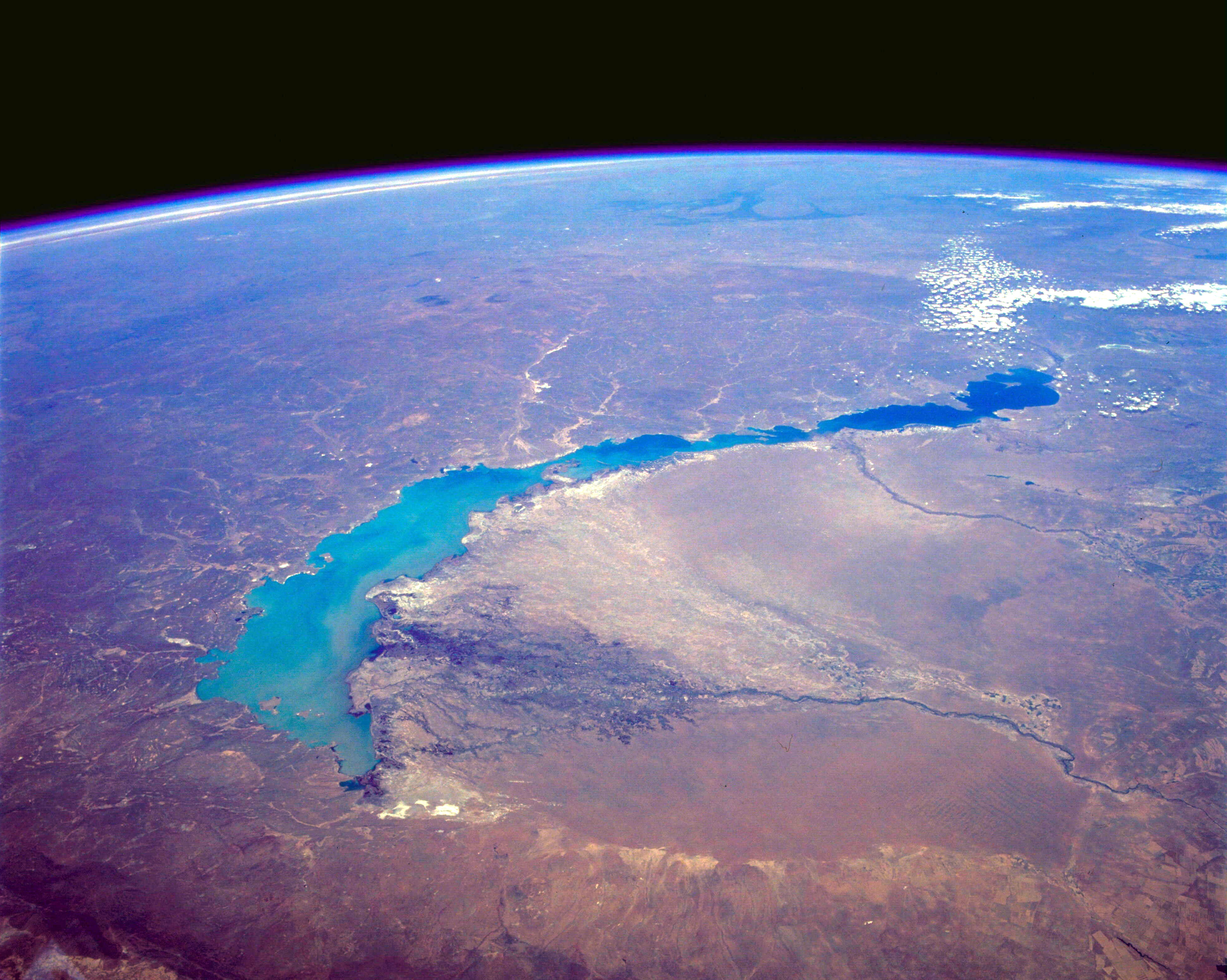
English: STS039-085-00E Lake Balkhash, Kazakhstan April 1991
The turquoise waters of Lake Balkhash can be seen in this northeast-looking, high-oblique photograph. The lake covers 6560 square miles (17 000 square kilometers), is nearly 350 miles (565 kilometers) long, but is only 45 miles (72 kilometers) at its maximum width. The average depth of Lake Balkhash is 20 feet (6 meters), but the lake reaches a maximum depth of 85 feet (26 meters) in its western half. Lake Balkhash extends from the Betpak Steppe in the west to the Kazakh Hills in the northeast. Visible in the photograph to the north of the lake is a vast undulating plain, and south-southeast of the lake are the Ili River and its delta. The Ili River separates two deserts. The larger, sandy Sary-Ishikotrau Desert lies northeast of the Ili River. A much smaller river, the Karatal, traverses this desert and empties into the eastern portion of Lake Balkhash. The Taukum Desert (brownish color) can be seen southwest of the Ili River. A large sandbar or spit (center of the photograph) separates the eastern, shallower, more saline part of Lake Balkhash from the deeper, fresher water of the western portion of the lake. The Ili River is fed by melting snow and glaciers of the Tien Shan ranges in China south of the lake (not visible in the photograph). Lake Balkhash has no river outlet and, even with the influx of fresh water from the Ili River, is shrinking because of evaporation; however, its rate of shrinkage is much less than that of the Aral Sea, which juts into Kazakhstan much farther to the west. |
| Дата | |
| Источник | http://eol.jsc.nasa.gov/sseop/EFS/photoinfo.pl?PHOTO=STS039-85-E |
| Автор | NASA |
Лицензирование
| Этот файл находится в общественном достоянии (англ. public domain), так как он был создан NASA (Национальным управлением по аэронавтике и исследованию космического пространства). Политика авторского права NASA гласит, что «Материал NASA не защищается авторским правом, если не указано иное». (См. Template:PD-USGov, страницу политики авторского права NASA или политику использования изображений JPL.) | ||
 |
Предупреждения:
|
Исходный журнал загрузок
Перенесено с en.wikipedia на Викисклад участником C messier при помощи CommonsHelper.
Первоначальная страница описания находилась здесь. Все нижеперечисленные имена участников относятся к en.wikipedia.
- 2012-05-29 09:52 Lukemcurley 3948×3153× (1846896 bytes) Cropped some of the black space from the top of the photo to focus on the lake.
- 2012-05-29 09:39 Lukemcurley 3960×4001× (1289732 bytes) Uploading a public-domain item using [[Wikipedia:File_Upload_Wizard|File Upload Wizard]]
История файла
Нажмите на дату/время, чтобы увидеть версию файла от того времени.
| Дата/время | Миниатюра | Размеры | Участник | Примечание | |
|---|---|---|---|---|---|
| текущий | 06:43, 18 февраля 2014 | | 3948 × 3153 (1,76 Мб) | OgreBot | (BOT): Reverting to most recent version before archival |
Использование файла
Следующая страница использует этот файл: